Stuff is expensive in Canada!
Milk is $7.47 gal; butter $4.17 a lb; gas $1 litre (multiply that by 3.8!); canned milk$1.79 ($.75 at Aldi every day); a small head of lettuce is $2.47 (usually $.88 - $1.29 at Aldi); couldn't find radishes;
People are super nice, a little too chatty at times.
Love:
Dollarama stores!
Maple crème cookies!
If you buy stamps at the post office, you will pay 5% tax on them; if you buy them anywhere else, you pay face value with no tax
Frenchy's or Guy's Frenchy's Used Clothing stores – mostly clothes sorted by size and are in large bins, jackets & dresses on hangers
thrift stores are very rare
a package of three 1-litre bags of milk
Mail boxes hanging by a chain or chains from a pole mounted on a 4x4
no-entry-possible front doors - some 3 or 4 feet above ground, one house had 2 stacked doors, even if at ground level they are without a stoop, steps, porch, no overhang or awning.
houses painted middle-of-the-road solid-line yellow or violent violet or royal blue, several houses painted dark purple with bright green trim; one new house had a bright yellow metal roof
On PEI, very few houses older than 1960 – or they are Victorian
In Quebec province, all the fire hydrants have two poles beside them and a tall pole with a yellow sign & hydrant in black shadow (so the snow plows can avoid them?)
Slaw is green: Dixie style is chopped very fine; vinegar I don't want to think about; regular is lime green colored and has pineapple & red pepper in it (it tasted ok but lacked enough celery seeds)
People back out of their driveways right out onto the major highway (think U.S. 1) even though the parking area and/or driveway is large enough to turn around in before getting onto the road.
Quite a few houses and some garages/barns wrapped in Tyvec with lathe nailed over it, some has been on so long that it is in shreds, most has been on more than a couple of years.
Thursday, June 24, 2010
Monday, June 21, 2010
Back through Maine, Into VT, NH, NY Because It's Almost Over
June 15, 2010
Our parking space last night turned out to be behind a small shopping mall along the seawall next to the marina. During the night, the wind got up really high and several times it seemed as if it would knock us over. The windows on the sea side were covered with salt spray and this morning the wind is still up with the incoming tide.
After leaving this morning as we were headed toward Riviere-du-loup, we passed several places where crews were repairing the seawall along the highway. We also passed by a new house with a dandelion yellow metal roof.
We again had a time finding the correct route though a town; we saw the sign directing us toward Edmundston, NB, but without a route number, then we saw route directional signs without a clue where they would take us. We finally found it and got on our way. The GPS battery died and I had to shut it down.
June 16, 2010
We headed down the road to Woodstock, NB, to cross the border and get on I-95 without incident (getting off on the wrong road!!). We left I-95 at Newport taking US 2 west traveling through Skowheagan, didn't find the 62-foot wooden Indian said to be on the north side of the road behind a gas station. We ended up getting a campsite outside Stowe, VT, as I wanted to take a tour of Ben & Jerry's and we had gotten there too late.
June 19,2010
Lost a day or two somewhere again!
We took the 15-minute tour of the original Ben & Jerry's ice cream plant outside Waterbury, VT, down the road from the campground, which was a hoot! The tour guide assured us that he was going to milk the history of the company. We mooooved through the small plant after watching a short mooovie about the founders and how the company has grown, there's even a plant in Israel. The ice cream is only sold to retailers in packs of eight of one flavor; only one flavor is made a day, it's only made in half and pint sizes, employees get three pints of their choice every day they work, and the flavor graveyard was at the top of a steep hill.
My favorite 'tombstone'

When we stopped at a Walmart Superstore in Plattsburg, NY, I was surprised at how crowded the parking lot and store were. Turned out that many Canadians shop at that store and the surrounding shopping center about twice a month and that was one of the days. We spent the night at the store in Ticonderoga to get away from the interstate noise only to have a couple long-distance truck drivers ride around the parking lot several times in the middle of the night.
We decided to just take our time getting to Front Royal enjoying the scenery expecting to arrive there Monday around noon.
Wednesday, June 16, 2010
Cavendish, New Brunswick, Again, and Gaspe
June 9, 2010
Last night about dusk, Frank saw a fat fox run across the grassy parking area we were parked in for the night.
By 7 a,m. we were sitting on a cliff overlooking the Gulf of St. Lawrence watching the fishing boats pulling their nets behind them. Just before 9 a,m. we left to go to the Green Gables complex where it's 'all about Anne' and her creator Lucy Maud Montgomery. I did get some photos of the inside of the house (below is "Anne's" bedroom)

It was modeled after her cousins' home for the “Anne” books. I walked the whole (1 K) Balsam Hollow Trail and understand why she loved those walks in the wooded areas around the site. It's very quiet except for the birds and has several foot bridges back and forth across a stream. Off the trail a short distance, I discovered a beavers' dam.
After lunch we arrived in Summerside to refill the propane tank, the gas tank, and visit another Dollarama, my very favorite Canadian store. After I cleared their shelf of my absolute favorite cookie that can only be found in Canada!, we went across the street to take a look around the County Fair Mall – which was touted as being “a country fair every day!” It had a Zeller (a Target like store), a Sobey grocery store, a medical clinic, and about a dozen small boutiques, and a narrow middle corridor. Nowhere did I see anything that resembled a 'county fair'!
That evening we stopped at the Red Shores at Summerside Raceway where we watched the first five of twelve harness racing events. My first pick came in first by a mile, and my second pick came in dead last after breaking stride about ¾ of the way around the track. Then a driver was thrown and had to be taken to the hospital so we left as it was getting dark anyway. We returned to the Walmart we had seen on the way there to park for the night.
June 10, 2010
After I got fresh bread and eggs, and several other items, we didn't need, we followed Rt. 12 north around the North Cape tip of the island, stopping to visit the Wind Farm Interpretive Centre and the lighthouse. We started noticing that all the churches have huge spires, only a very few had none, three or four had four stubby spike like spires on the four corners of the tower.

This museum is dedicated to the history of the potato and how it changed the lives of the pioneers to PEI. The kitchen where all kinds of potato recipes are shown was closed. I did get a recipe for potato fudge, though. Just on PEI the farmers grow more than a dozen different varieties.

THIS IS MY DOLLHOUSE!!!! Why is it in their museum????
We worked our way around the west side of the island until we arrived at the Potato Museum in O'Leary. As it was getting to be 5 p.m. we headed for the closest provincial park to spend the night. It was getting hot, the wind died down, and the mesquites were swarming.
June 11, 2010
We left the campsite this morning and headed down the road to Cap-Egmont to see the Bottle Houses created by a man during his retirement years, now his son and grandson maintain the buildings.

Then we went on to Summerside again to do laundry and then to the Confederation bridge to get back over to New Brunswick to follow the Acadian Coastal Drive. We stopped at the Irving Eco-Centre, La Dune Bouctouche which has a wooden walkway that snaked along the dunes for miles (so it seemed) and I only managed about a half or maybe a third before turning back.

Planning to stop in Miramichi for the night, I used the GPS to find the place we wanted only to have it tell me to make a left turn then it said, “Make a legal U turn as soon as possible,” taking us right back to where we should have made a right turn like the map said to do; then further down the road it told us to make a right turn on the wrong side of the river! We finally made it to our overnight parking place.
June 12, 2010
While we were sitting in the hardware store parking lot waiting for it to open this morning at 8:30 a.m. (on a Saturday!), a former long-distance truck driver stopped to ask if we needed help thinking we had broken down. Then he tells us that we can park in his yard with full hookups for several days if we would like!
After we got the metal washers and rubber things needed to fix the front end of the RV, we headed on up the road to stop at the Acadian Historical Village outside Caraquet only to find out it didn't open til the next day. Nothing that I saw or read anywhere said that it was only open from June 13th til whenever this year.
We did stop in Bereford to check out the beach boardwalk and it was somewhat disappointing. It's not nearly as long as the one at Bouctouche. Plus the beach is very rocky, littered with broken shells, tree limbs, and sea weed. I think they brought in about three cubic yards of sand to make a 'beach' for children to play on and run in and out of the shallow, waveless water.
Hardly any English is spoken in this area of New Brunswick....we're crossing into Quebec tomorrow morning to tour the Gaspe peninsula and that's about all that's spoken in that province!
June 13, 2010
Spending the night in the Sobey's parking lot in Campbellton, NS, we left at 6 a.m. for Perce to go whale watching. Once we crossed into Quebec province, we noticed a definite difference in the terrain! It suddenly became mountainous with steep hills and many curves to slow us down. We were taking our time anyway.
We arrived in Perce just in time to catch the 1:30 p.m. cruise...in fact the ticket seller called the boat to return to the wharf to pick us up.

Only about twelve people were on the boat, one man in a wheelchair. Off we went into 20 kph winds in a large bass boat! It took about 20 minutes to get about eight miles off shore to start looking for the whales....we were being raced by three or four dolphins just before we caught sight of the first of many whales spotted. Unfortunately, two of the women got sick from the rocking, rolling, and tossing about we did most of the time we were out. Amazingly, I didn't get the least bit sick.
June 14, 2010
Leaving the Fort Ramsey campground this morning, we continued following Rt 132 around the very end of the Gaspe peninsula. We stopped at several picnic areas along the coast to try to spot sea creatures without luck. The scenery is spectacular!! We would top a hill and look down on a picturesque seaside village. We are seeing actual ocean waves again; before the shore line was like the Gulf of Mexico – little or no waves at all, now we can see actual swells.
Around dinner time, we arrived in Matane, and as we had been seeing a restaurant called 'Dixie Lee' in just about every town along the way in the other provinces too, we decided to have dinner there. As luck would have it, not one person in the tiny store we finally found could speak English. It was a fast-food restaurant serving several versions of chicken, seafood, and only pepperoni and cheese pizza or with everything on it so we ordered the everything-on-it pizza which turned out to be pepperoni, cheese, mushrooms, and green peppers! It was really, really good, though.
Wednesday, June 9, 2010
Prince Edward Island
I just realized I've lost a day somewhere! Maybe I should keep using dates! Although some days are just spent traveling down the road with nothing but beautiful scenery....and the usual horrible road conditions.
June 6
Leaving about the time the sun came up, we picked up the Sunrise Trail in Nova Scotia following the coast line back down the island until we arrived at the Confederation Bridge. This is an eight-mile long two-lane span from New Brunswick to Prince Edward Island. Thank God it was a foggy day so I was unable to see just how far up we were or how long that bridge really was. Fifteen minutes is the average travel time....luckily, traffic was light. We stopped at the Visitors' Centre complex to have a look around and pick up some brochures and a map. We only went a few miles further and found a campsite for the night.
June 7
We were late leaving the campground because of needing to get some laundry done. We then traveled east on Rt 1 then picked up Rt 4 after leaving Charlottetown. We had fresh lobster with baked P.E.I. potato, slaw and a drink for dinner in Montague then spent the night in the parking lot of the Atlantic Super Store.
June 8
My GPS says we are currently 1,918 miles from home.
From Montague we followed the Points East Coastal Drive around the eastern tip of the island. At Souris, we suddenly came upon a detour because the main street was completely torn up for several blocks. We were directly into the parking lot of the Home Store and had to guess where the detour was. We got lost and ended up on a dead end street. Danny lead us out the back way (still unmarked) to our route.
We continued on around the end of the island to Priest Pond where the bridge was completely gone and had another detour! This detour sent us right back to the other side of the island, down to Souris and back across the island to Hermanville, about a 40-mile detour and ended up only about five miles further down the right road.
Feeling we were finally on our way this time, we tried to make up some time but the route was terrible....missed turns, travelling down a road to discover we were on the wrong one, AGAIN!!

The highlight of the day was seeing the little fox bopping down the road in front of us. We stopped, she stopped, and I got some photos.
We finally ended up in Cavendish which is all devoted to 'all things Anne'. After checking out the location of what I wanted to see the next day, we decided to spend the night at the Visitors' Centre parking lot.
Monday, June 7, 2010
Nova Scotia Part 2 - Digby & Peggy's Cove
31 May 2010
The wind started howling early in the evening and continued into the next day. It looked like a strong storm was rolling in but it never rained.
From the tidal chart we could tell that the Fundy Tidal Bore event wouldn't happened until about 2 p.m. We decided to head for South Maitland and the Tidal Bore Interpretive Centre and just look around until then. Again, the GPS couldn't find the address nor the name given in the brochure. Again, because of poor signage, we probably went about 20 miles out of our way before we got onto the correct route to the place. And what a rough, narrow, messed up paved potholes road it was for about 50 miles and the wind was still howling and pushing the RV back and forth. When we arrived, the sign was bland and gave a different name for the place! One day soon, we're going to figure out how to trick the GPS into giving us the correct directions for where we are trying go to without it taking us back into the US or in the opposite direction.
A tidal bore event is when the incoming tide pushes the outgoing river back up the river bed, usually can only be seen where the river is in a narrow channel. Today we noticed a thin, small crest of water coming up the river; as it continued up river, the water level started to rise and continued to rise for about twenty minutes. Several rafts full of people raced along with the crest and stopped under the bridge before heading back down river to the staging area. We saw signs posted warning of coyote activity in the area with instructions on how to avoid an attack. We left a little while later and found a campsite for the night outside Aylesford.
1 June 2010
Today was spent going to Annapolis Royal and trying to locate Fort Royal Habitation 1605 somewhere in the area. After getting directions from two different people about the location of the visitors' centre and getting two different locations, we finally found out that it is called Fort-Royal and Melanson Settlement and are on the same road but two separate places with a third part called Fort Anne in town. We walked around the Melanson Settlement reading the plaques then continued down the road apiece to the fort.
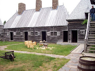
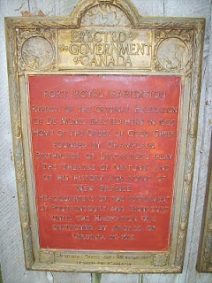
This is similar to the Jamestown Settlement in that it is a complete reconstruction made from records.
Then we decided to drive down Digby Neck to watch for whales (as advertised in the brochures).
We arrived several hours before high tide, said to be the time they travel through this area, and parked beside the car ferry from East Ferry to Tiverton on Long Island. The ferry
went back and forth, mostly carrying pickup trucks, for about two hours as the fog slowly crept in, hiding the small lighthouse on Long Island. High tide was to be around 4 p.m. but we didn't see any whales or seals, just gulls, the ferry boat, and some fishing boats in the harbor.
We returned to Digby to find the Fundy Restaurant to have a seafood dinner...parking on the main thoroughfare where it is located was too tight for our RV so we went to the restaurant recommended by the woman at the visitors' centre. After a great meal and a very friendly waitress, we returned to the visitors' center to park for the night.
June 2, 2010
We found Peggy's Cove just before Halifax and took the detour to view this famous village and lighthouse.

This place was very rocky and I mean boulders every where with almost no grass, narrow winding street, steep hills, to the lighthouse and restaurant & gift shop. After about an hour we continued on to Halifax.
The less said about our attempts to find parking in Halifax....the better. And getting out of town was awful...signage here is terrible and you never know when the route numbers are going to change! We ended up spending the night at the Atlantic Super Store parking lot along with two tour buses, a tractor trailer and another RV, when we took a wrong turn off the 'freeway' and ended up going back the way we had come because we couldn't read the signage in the dark. Even though the signs were lighted, the part where the route numbers were at the top of the sign was in shadow making them hard to see clearly.
The next morning, we traveled up Rt 7/107 and then Rt 211 to the ferry dock (which was closed) not realizing that was the only way to continue onto Rt 316. We had to backtrack about 20 miles and return to Rt 7 to Melrose, using Rt 348 to Country Harbour Cross Roads to get to Rt 316. Still heading east, we took a right onto Rt 16 to Canso to get a campsite. Canso has a sign at the only road in or out saying it was established in 1604! It's clearly a fishing village. Our campsite was on the dockside. The roads getting here were horrible; we think worse than the Alaska Hwy ever was!
We noticed a strange sign while on the 100 series controlled access highways around here: a sign would say “No turn at the intersection” which usually turned out to be a gravel road, sometimes a paved one, which cut across the road.
June 3, 2010
From Canson we traveled up into the Cape Breton highlands stopping in Cheticamp just west of the national park. We had been taking our time getting that far, stopping often just to take advantage of the overlooks along the route. Our first stop was at the Visitors' Center which was closed. Directly behind the building was an arena with a huge parking lot so we spent the night there.
June 4, 2010
Today was spent traveling the Cabot Trail, the highway that loops around the Cape Breton Highlands National Park. This route features many overlooks and grades as steep as 13 percent. We stopped often and I took lots of photos. Near the eastern most point of the park, we saw several patches of snow in the ditch along side the road. We kept seeing signs for whale watching cruises but exited the park realizing we hadn't seen any of the businesses! The one we did see was closed until June 19th.
Sunday, June 6, 2010
Are We There Yet??
Once we left I-81 in PA and got on I-84 heading east, the construction nightmares began. For several miles all we saw were the orange and white striped construction barrels in our lane with no workers or equipment in sight. We also had to cross over a long toll bridge while following escort vehicles going very slowing because a crew in a pickup truck in front of them was filling in potholes in the far right lane.
This Paul Bunyan statue was in a small park in front of the civic center just off Main Street in Bangor.
We left Bangor, ME headed down Alt. US 1 to Ellsworth not realizing it was under major reconstruction from the roadbed being regraded to complete realignment with repaving. This was for miles and miles. after lunch we continued on to Bar Harbor and Acadia National Park.
This park was not what we expected: the major scenic twenty-seven mile route was inaccessible because of low height restrictions where the road went under overpasses. Clearly the founders and designers of this park in the early 1900s got exactly what they wanted: no auto traffic. the route is also a one-way ten-foot wide road. We ended up taking the less scenic route following Rt. 3 then returning to Ellsworth thinking we would go north on Alt. US 1 to Calais to cross into Canada.
I attempted to use the new GPS to get us on that route and on our way. It took us almost all the way back to Bangor through all that construction and off onto a short cut to Rt 9 into Calais where we did cross over into Canada. We were instructed to pull over to a covered multilaned area for a search by an inspector.....the RV would not go under it and after the search we had to back out. We continued on to St. Stephens where the GPS instructed us to go around a route that was not showing up on the screen and we found ourselves at a tiny crossing back into the US. About 15 minutes later we had returned to the Calais crossing and got back into Canada and told to turn the GPS off and to stay on that highway to get to Saint John.

We found the Reversing Falls viewing site without a problem as it was well signed. When the tide rolls in, it creates whirlpools and causes the 'falls' to appear to reverse going up river.
Getting back on the road going in the right direction was a biggie! The signs are confusing and took us through downtown crossing over the route we wanted but without on ramps. We took the one we thought would get us on only to find out we were going back southwest. The next exit then carried us way, way down a road without any place to turn around. Finally we were able to see up on the on ramp enough that we could take a left turn and get back on that road and return to Saint John going northeast and Hopewell Rocks.
We traveled to New River Provincial Park to get a camp site for the night. The next day we traveled through Fundy National Park to get to Alma and Hopewell Rocks. We were way too late to get on the beach for low tide but I decided to stroll down to the viewing area just to take a look and some photos at high tide. The steel staircase was about 8 levels down to the ramp onto the beach. By the time I climbed back up, I was so winded I had to take the shuttle up to the parking lot. We decided to return the next day for the low tide event.


Stopping in Alma, we bought a lobster for Frank and a half pound of scallops for me at the Lobster Shack. It was really, really good. I couldn't finish that many scallops so Frank ate a couple.
Our campsite that night was in the only open campground in the National Park not far from Alma, one pump gas station/quick stop. We think the entry pass and campsite of $48 CA is way too much when the provincial park campsite was $22 CA.
We got to Hopewell Rocks just as it opened and walked down to the beach. (photos to be posted later!)
Leaving Hopewell Rocks, and using the GPS, I tried to locate either a RBC or Scotia Bank ATM without success. We got turned around in Moncton, then were able to get onto the correct route to Sackville where both banks had ATMs. Then we were back on the road to Truro, NS, to visit the Glooscap Heritage Centre that closed before we got there so we went on down the road to a private campground where we could not get leveled up as much as we would have liked. So far the weather has been clear but it certainly is cold: down in the 40's at night and only about 65 in the day.
We decided to remove Newfoundland from this trip as that would eliminate a little over a 1,000 miles and a week of time plus it's taking longer to get from one point to another and the price of gas here in Canada is at least $1 more than in the States. Plus taking these side roads is also eating into the mpg.
Subscribe to:
Posts (Atom)